Road Information |
||
 |
||
| Total Mileage in State: | 128 miles | |
| Northern End: | At Iowa state line | |
| Southern End: | At I-70, in Kansas City | |
| Mileage covered in Photos: | 128 miles | |
| Counties covered in Photos: | Atchison, Holt, Andrew, Buchanan, Platte, Clay, Jackson | |
| Major Junctions in Photos: | US 136, in Rock Port I-229 South, near St. Joseph I-229 North, near St. Joseph I-435 South, in Platte City I-435 East, in Kansas City I-635, in Kansas City I-70, in Kansas City |
|
| Control Cities in Photos: | Rock Port, St. Joseph, Platte City, North Kansas City, Kansas City | |
Southbound
- Section 1: Iowa Border to St. Joseph (Exit 53)
- Section 2: St. Joseph (Exit 53) to Kansas City (Exit 8)
- Section 3: Kansas City (Exit 8) to Interstate 70 (Southern Terminus)
Section 1: Iowa Border to St. Joseph (Exit 53)
 |
Interstate 29 South as it crosses into Missouri from Iowa. (Photo taken 8/10/20). |
 |
The speed limits on Interstate 29 South in Missouri start out at 70 mph maximum and 40 mph minimum. These are the standard speed limits on most rural Interstate highways in Missouri. (Photo taken 8/10/20). |
 |
Missouri welcome sign on Interstate 29 South. (Photo taken 8/10/20). |
 |
Mile marker 123.4 on Interstate 29 South in Atchison County. (Photo taken 8/10/20). |
 |
Interstate 29 South approaching the Weigh Station in Atchison County. I get a kick out of the misspelling of the word 'Buses'. (Photo taken 8/10/20). |
 |
Weigh Station on Interstate 29 South at mile marker 121.6 in Atchison County. (Photo taken 8/10/20). |
 |
View on Interstate 29 South at mile marker 120. (Photo taken 8/10/20). |
 |
Interstate 29 South at mile marker 119. (Photo taken 8/10/20). |
 |
Mile marker 117.4 on Interstate 29 South in Atchison County. (Photo taken 8/10/20). |
 |
Interstate 29 South at Exit 116: Route A / Route B - Watson (Photo taken 8/10/20). |
 |
State-named Interstate 29 South reassurance shield at mile marker 115.6. (Photo taken 8/10/20). |
 |
Interstate 29 South at mile marker 113. (Photo taken 8/10/20). |
 |
Take Exit 110 to Tarkio and Northwest Missouri State University. (Photo taken 8/10/20). |
 |
Interstate 29 South at Exit 110: US 136 - Rock Port / Brownville, NE (Photo taken 8/10/20). |
 |
Rest Area / Welcome Center on Interstate 29 South at mile marker 110 in Atchison County. (Photo taken 8/10/20). |
 |
Mileage sign on Interstate 29 South. It's 17 miles to Craig and 61 miles to St. Joseph. (Photo taken 8/10/20). |
 |
Interstate 29 South at Exit 107: MO 111 - Rock Port / Langdon (Photo taken 8/10/20). |
 |
View on Interstate 29 South at mile marker 106.4. (Photo taken 8/10/20). |
 |
Mile marker 104 on Interstate 29 South in Atchison County. (Photo taken 8/10/20). |
 |
Interstate 29 South at mile marker 102. (Photo taken 8/10/20). |
 |
View on Interstate 29 South at mile marker 101. (Photo taken 8/10/20). |
 |
Interstate 29 South at Exit 99: Route W - Corning (Photo taken 8/10/20). |
 |
Interstate 29 South as it enters Holt County at Exit 99. (Photo taken 8/10/20). |
 |
Another Interstate 29 South reassurance shield. (Photo taken 8/10/20). |
 |
View on Interstate 29 South at mile marker 96. (Photo taken 8/10/20). |
 |
Interstate 29 South at mile marker 94. (Photo taken 8/10/20). |
 |
Interstate 29 South at Exit 92: US 59 - Craig / Fairfax (Photo taken 8/10/20). |
 |
Mile marker 90 on Interstate 29 South in Holt County. (Photo taken 8/10/20). |
 |
View on Interstate 29 South at mile marker 89. (Photo taken 8/10/20). |
 |
Interstate 29 South at mile marker 87. (Photo taken 8/10/20). |
 |
View on Interstate 29 South at mile marker 86. (Photo taken 8/10/20). |
 |
Take Exit 84 to Big Lake State Park. (Photo taken 8/10/20). |
 |
Interstate 29 South at Exit 84: MO 118 - Mound City (Photo taken 8/10/20). |
 |
Another mileage sign on Interstate 29 South. It's 35 miles to St. Joseph and 88 miles to Kansas City. (Photo taken 8/10/20). |
 |
View on Interstate 29 South at mile marker 82.8. (Photo taken 8/10/20). |
 |
Truck Parking Area on Interstate 29 South at mile marker 81.8 in Holt County. (Photo taken 8/10/20). |
 |
Interstate 29 South at mile marker 81.2. (Photo taken 8/10/20). |
 |
Mile marker 80.4 on Interstate 29 South in Holt County. (Photo taken 8/10/20). |
 |
Take Exit 79 to Loess Bluffs National Wildlife Refuge. (Photo taken 8/10/20). |
 |
Interstate 29 South at Exit 79: US 159 - Rulo, NE (Photo taken 8/10/20). |
 |
View on Interstate 29 South at mile marker 77.6. (Photo taken 8/10/20). |
 |
Interstate 29 South at Exit 75: US 59 - Oregon (Photo taken 8/10/20). |
 |
View on Interstate 29 South at mile marker 73. (Photo taken 8/10/20). |
 |
Mile marker 72 on Interstate 29 South in Holt County. (Photo taken 8/10/20). |
 |
View on Interstate 29 South at mile marker 69. (Photo taken 8/10/20). |
 |
Interstate 29 South at Exit 67: US 59 North - Oregon (Photo taken 8/10/20). |
 |
Interstate 29 South as it enters Andrew County. (Photo taken 8/10/20). |
 |
Interstate 29 South at Exit 65: US 59 / Route RA - Savannah / Fillmore (Photo taken 8/10/20). |
 |
State-named Interstate 29 South reassurance shield. (Photo taken 8/10/20). |
 |
Speed limit signs on Interstate 29 South. The speed limits remain the rural standard 70 mph maximum and 40 mph minimum. (Photo taken 8/10/20). |
 |
Mileage sign on Interstate 29 South. It's 8 miles to the junction of Interstate 229, 17 miles to St. Joseph, and 69 miles to Kansas City. (Photo taken 8/10/20). |
 |
Mile marker 63 on Interstate 29 South in Andrew County. (Photo taken 8/10/20). |
 |
Interstate 29 South at mile marker 62. (Photo taken 8/10/20). |
 |
Interstate 29 South at Exit 60: Route CC / Route K - Amazonia (Photo taken 8/10/20). |
 |
Take any of the next 7 exits to St. Joseph. (Photo taken 8/10/20). |
 |
Advance signage for the junction of Interstate 229 South / US 71 / US 59 via Exits 56B-A - 1 mile ahead. (Photo taken 8/10/20). |
 |
Interstate 29 South at Exit 56B: Interstate 229 South - Downtown St. Joseph (Photo taken 8/10/20). |
 |
At mile marker 57 (and the gore point signage of the ramp for Exit 56B), this warning sign on the left alerts motorists that traffic from US 71 / US 59 will be merging into the southbound lanes of Interstate 29 ahead on the left. (Photo taken 8/10/20). |
 |
Interstate 29 South at Exit 56A: US 71 North / US 59 North - Maryville (Photo taken 8/10/20). |
 |
Mile marker 55 on Interstate 29 South in Andrew County. (Photo taken 8/10/20). |
 |
Interstate 29 South at Exit 53: Interstate 29 Business Loop / US 71 Business / US 59 - Savannah / St. Joseph (Photo taken 8/10/20). |
Section 2: St. Joseph (Exit 53) to Kansas City (Exit 8)
 |
Interstate 29 South at mile marker 52.2. (Photo taken 8/10/20). |
 |
Interstate 29 South as it enters Buchanan County. (Photo taken 8/10/20). |
 |
Interstate 29 South at Exit 50: US 169 - King City / St. Joseph (Photo taken 8/10/20). |
 |
Another Interstate 29 South reassurance shield entering the St. Joseph city limits. (Photo taken 8/10/20). |
 |
Mileage sign on Interstate 29 South. It's 3 miles to the junction of MO 6 and 55 miles to Kansas City. (Photo taken 8/10/20). |
 |
View on Interstate 29 South at mile marker 49. (Photo taken 8/10/20). |
 |
The maximum speed limit decreases to 65 mph on Interstate 29 South as it gets close to downtown St. Joseph. Take Exit 47 to the Museums and a Tourist Information Center. (Photo taken 8/10/20). |
 |
Interstate 29 South at Exit 47: MO 6 - Frederick Ave / Clarksdale (Photo taken 8/10/20). |
 |
Another speed limit sign at mile marker 47.4. While the maximum speed limit has decreased to 65 mph for the time being, the minimum speed limit remains 40 mph. (Photo taken 8/10/20). |
 |
Take Exit 46A to Missouri Western State University. (Photo taken 8/10/20). |
 |
Interstate 29 South at Exit 46B: US 36 West - St. Joseph (Photo taken 8/10/20). |
 |
Interstate 29 South at Exit 46A: US 36 East - Cameron (Photo taken 8/10/20). |
 |
Interstate 29 South at Exit 44: US 169 / Interstate 29 Business Loop - Gower / St. Joseph (Photo taken 8/10/20). |
 |
At mile marker 44, the maximum speed limit increases to the rural standard 70 mph once again as Interstate 29 South leaves the St. Joseph area. The minimum speed limit remains the usual 40 mph. (Photo taken 8/10/20). |
 |
Advance signage for Exit 43 - 1/2 mile ahead. (Photo taken 8/10/20). |
 |
Interstate 29 South at Exit 43: Interstate 229 North - St. Joseph (Photo taken 8/10/20). |
 |
Mile marker 43 on Interstate 29 South, as traffic from Interstate 229 South merges into it on the right. (Photo taken 8/10/20). |
 |
State-named Interstate 29 South reassurance shield. (Photo taken 8/10/20). |
 |
Mile marker 41 on Interstate 29 South in Buchanan County. (Photo taken 8/10/20). |
 |
View on Interstate 29 South at mile marker 39. (Photo taken 8/10/20). |
 |
Interstate 29 South at mile marker 37. (Photo taken 8/10/20). |
 |
Interstate 29 South at Exit 35: Route DD - Faucett (Photo taken 8/10/20). |
 |
View on Interstate 29 South at mile marker 34. (Photo taken 8/10/20). |
 |
Mile marker 31.8 on Interstate 29 South in Buchanan County. (Photo taken 8/10/20). |
 |
Interstate 29 South as it enters Platte County at mile marker 31. (Photo taken 8/10/20). |
 |
Interstate 29 South at Exit 30: Route Z / Route H - Dearborn / New Market (Photo taken 8/10/20). |
 |
The speed limits remain the rural standard 70 mph maximum and 40 mph minimum. (Photo taken 8/10/20). |
 |
Mileage sign on Interstate 29 South. It's 4 miles to the junction of Route E / Route U and 33 miles to Kansas City. (Photo taken 8/10/20). |
 |
View on Interstate 29 South at mile marker 29. (Photo taken 8/10/20). |
 |
Rest Area on Interstate 29 South at mile marker 27.4 in Platte County. (Photo taken 8/10/20). |
 |
Interstate 29 South at Exit 25: Route E / Route U - Camden Point (Photo taken 8/10/20). |
 |
Truck Parking Area on Interstat 29 South at mile marker 24.2 in Platte County. (Photo taken 8/10/20). |
 |
Interstate 29 South at mile marker 22.2. (Photo taken 8/10/20). |
 |
Take Exit 20 to Weston Bend State Park and Lewis and Clark State Park. (Photo taken 8/10/20). |
 |
Interstate 29 South at Exit 20: MO 273 North - Tracy / Weston (Photo taken 8/10/20). |
 |
Interstate 29 South at Exit 19: Route HH - Main St (Photo taken 8/10/20). |
 |
Advance signage for the junction of Interstate 435 via Exit 17, which is now 1 mile ahead. (Photo taken 8/10/20). |
 |
Take Exit 18 to Smithville Lake. (Photo taken 8/10/20). |
 |
Interstate 29 South at Exit 18: MO 92 - Smithville / Platte City (Photo taken 8/10/20). |
 |
Interstate 29 South at Exit 17: Interstate 435 South - Topeka (Photo taken 8/10/20). |
 |
Gore point signage for Exit 17 as Interstate 29 South prepares to combine with the eastbound (Inner Loop) lanes of Interstate 435 for a brief concurrency in the northern suburbs of Kansas City. (Photo taken 8/10/20). |
 |
Mile marker 17.6 on Interstate 29 South, as it prepares to pass under the ramps to and from Interstate 435 ahead. (Photo taken 8/10/20). |
 |
View on Interstate 29 South at mile marker 17.4, as its two lanes pass under the ramps to and from Interstate 435. (Photo taken 8/10/20). |
 |
At mile marker 17, Interstate 29 South enters the Kansas City city limits for the first time. As you can tell, since we're still about 20 miles from downtown, the Kansas City city limits stretch out quite a bit to the north. (Photo taken 8/10/20). |
 |
State-named Interstate 29 South / Interstate 435 East reassurance shields as Interstate 435 Inner Loop (East) traffic combines with the two remaining southbound lanes of I-29. This concurrency between I-29 and I-435 will last for the next 2 1/4 miles. During it, the mileage and exit numbers will be based on the total mileage of I-29 in Missouri. (Photo taken 8/10/20). |
 |
Speed limit signage at mile marker 16.6. The speed limits on the Interstate 29 South / Interstate 435 Inner Loop (East) concurrency remain the rural standard 70 mph maximum and 40 mph minimum. (Photo taken 8/10/20). |
 |
Take Exit 15 to KCI Economy Parking and the Air Cargo area. (Photo taken 8/10/20). |
 |
Interstate 29 South / Interstate 435 Inner Loop (East) at Exit 15: Mexico City Ave (Photo taken 8/10/20). |
 |
As this overhead signage shows, the right lane of the Interstate 29 South / Interstate 435 Inner Loop (East) duplex will become an Exit Only lane ahead, as I-29 and I-435 depart from one another. (Photo taken 8/10/20). |
 |
More signage showing that Interstate 435 Inner Loop (East) traffic should keep right ahead and use the two right lanes. Interstate 29 South thru traffic should stay straight ahead. (Photo taken 8/10/20). |
 |
Interstate 29 South / Interstate 435 Inner Loop (East) at Exit 14: Interstate 435 East - St. Louis (Photo taken 8/10/20). |
 |
A closer view of the ramp for Exit 14, as Interstate 435 Inner Loop (East) departs Interstate 29 South. (Photo taken 8/10/20). |
 |
View on Interstate 29 South at mile marker 14.2, as it begins to curve back to the south to begin heading toward downtown Kansas City. (Photo taken 8/10/20). |
 |
Interstate 29 South at Exit 13: Kansas City International Airport (Photo taken 8/10/20). |
 |
Another state-named Interstate 29 South reassurance shield at mile marker 13. (Photo taken 8/10/20). |
 |
Interstate 29 South at Exit 12: NW 112th Street (Photo taken 8/10/20). |
 |
The speed limits remain 70 mph maximum and 40 mph minimum on Interstate 29 South. (Photo taken 8/10/20). |
 |
View on Interstate 29 South at mile marker 11.2. (Photo taken 8/10/20). |
 |
Interstate 29 South at Exit 10: Tiffany Springs Pkwy (Photo taken 8/10/20). |
 |
Interstate 29 South at Exit 9B: MO 152 West - Topeka (Photo taken 8/10/20). |
 |
Interstate 29 South at Exit 9A: MO 152 East - Liberty (Photo taken 8/10/20). |
 |
Interstate 29 South at Exit 8: NW Barry Rd (Photo taken 8/10/20). |
Section 3: Kansas City (Exit 8) to Interstate 70 (Southern Terminus)
 |
Another state-named Interstate 29 South reassurance shield as the maximum speed limit decreases to 65 mph. (Photo taken 8/10/20). |
 |
Interstate 29 South at mile marker 7.8. (Photo taken 8/10/20). |
 |
Interstate 29 South at Exit 6: NW 72nd St / Platte Woods (Photo taken 8/10/20). |
 |
Take Exit 5 to Historic Downtown Parkville. (Photo taken 8/10/20). |
 |
Interstate 29 South at Exit 5: MO 45 North - NW 64th St (Photo taken 8/10/20). |
 |
Interstate 29 South at mile marker 5.6. (Photo taken 8/10/20). |
 |
Advance signage for Exits 3B-C, which is the junction of Interstate 635. The interchange is 1 mile ahead. (Photo taken 8/10/20). |
 |
Approaching Exits 3B-C, the maximum speed limit on Interstate 29 South decreases to 55 mph. The minimum speed limit remains 40 mph as usual. (Photo taken 8/10/20). |
 |
Interstate 29 South at Exit 3B: Interstate 635 South - Kansas (Photo taken 8/10/20). |
 |
Interstate 29 South at Exit 3C: NW Gateway / Riverside (Photo taken 8/10/20). |
 |
Overhead mileage sign on Interstate 29 South, listing the distances to its next three interchanges. (Photo taken 8/10/20). |
 |
Advance overhead APL signage for Exits 2B-A - 1/2 mile and 1 mile ahead, respectively. (Photo taken 8/10/20). |
 |
Interstate 29 South as it enters Clay County. (Photo taken 8/10/20). |
 |
Interstate 29 South at Exit 2B: US 169 South - Kansas City / Downtown (Photo taken 8/10/20). |
 |
Interstate 29 South at Exit 2A: US 169 North - Smithville (Photo taken 8/10/20). |
 |
Interstate 29 South at Exit 1E: US 69 - Vivion Rd (Photo taken 8/10/20). |
 |
Take Exit 1C to Gladstone. (Photo taken 8/10/20). |
 |
Interstate 29 South at Exit 1D: MO 283 South - Oak Trafficway (Photo taken 8/10/20). |
 |
Take Exit 1C to Midwestern Baptist Seminary. (Photo taken 8/10/20). |
 |
Interstate 29 South at Exit 1C: Oak Trafficway North (Photo taken 8/10/20). |
 |
Advance signage for Exit 1B at mile marker 1.2. The right lane will become an Exit Only lane for Exit 1B ahead. (Photo taken 8/10/20). |
 |
Interstate 29 South at mile marker 1. (Photo taken 8/10/20). |
 |
Interstate 29 South at Exit 1B: Interstate 35 North - Des Moines (Photo taken 8/10/20). |
 |
Interstate 29 South at Exit 1A: Davidson Rd (Photo taken 8/10/20). |
 |
Mile marker 0.4 on Interstate 29 South. Despite its marked mileage coming to an end ahead, I-29 South will continue concurrently with Interstate 35 South ahead to downtown Kansas City. (Photo taken 8/10/20). |
 |
Advance signage for Exit 8A - 1/4 mile ahead. We see Interstate 29 South briefly reduced to a single lane here as it prepares to join the southbound lanes of Interstate 35, seen off to the left. Exit 8A is the first exit once the concurrency begins. (Photo taken 8/10/20). |
 |
View on Interstate 29 South as it merges with the southbound lanes of Interstate 35, and their concurrency begins just before Exit 8A. During the concurrency, the mileage and exit numbers will be based of the total mileage of I-35 in Missouri. (Photo taken 8/10/20). |
 |
Interstate 29 South / Interstate 35 South at Exit 8A: Parvin Rd (Photo taken 8/10/20). |
 |
The speed limits remain 55 mph maximum and 40 mph minimum on Interstate 29 South / Interstate 35 South. (Photo taken 8/10/20). |
 |
Take either of the next 2 exits to North Kansas City. (Photo taken 8/10/20). |
 |
Interstate 29 South / Interstate 35 South at Exit 6: MO 210 - Armour Rd (Photo taken 8/10/20). |
 |
View of downtown Kansas City on Interstate 29 South / Interstate 35 South at mile marker 6.8. (Photo taken 8/10/20). |
 |
Another view of downtown Kansas City from Interstate 29 South / Interstate 35 South approaching Exit 5. (Photo taken 8/10/20). |
 |
Interstate 29 South / Interstate 35 South at Exit 5: Levee Rd (Photo taken 8/10/20). |
 |
State-named Interstate 29 South / Interstate 35 South reassurance shields. (Photo taken 8/10/20). |
 |
Overhead mileage sign listing the distances to the final three exits on the Interstate 29 South / Interstate 35 South concurrency. (Photo taken 8/10/20). |
 |
At mile marker 5.2, Interstate 29 South / Interstate 35 South start across the Christopher S. Bond Bridge over the Missouri River. (Photo taken 8/10/20). |
 |
Another set of state-named Interstate 29 South / Interstate 35 South reassurance shields as the duplex crosses the Christopher S. Bond Bridge over the Missouri River. (Photo taken 8/10/20). |
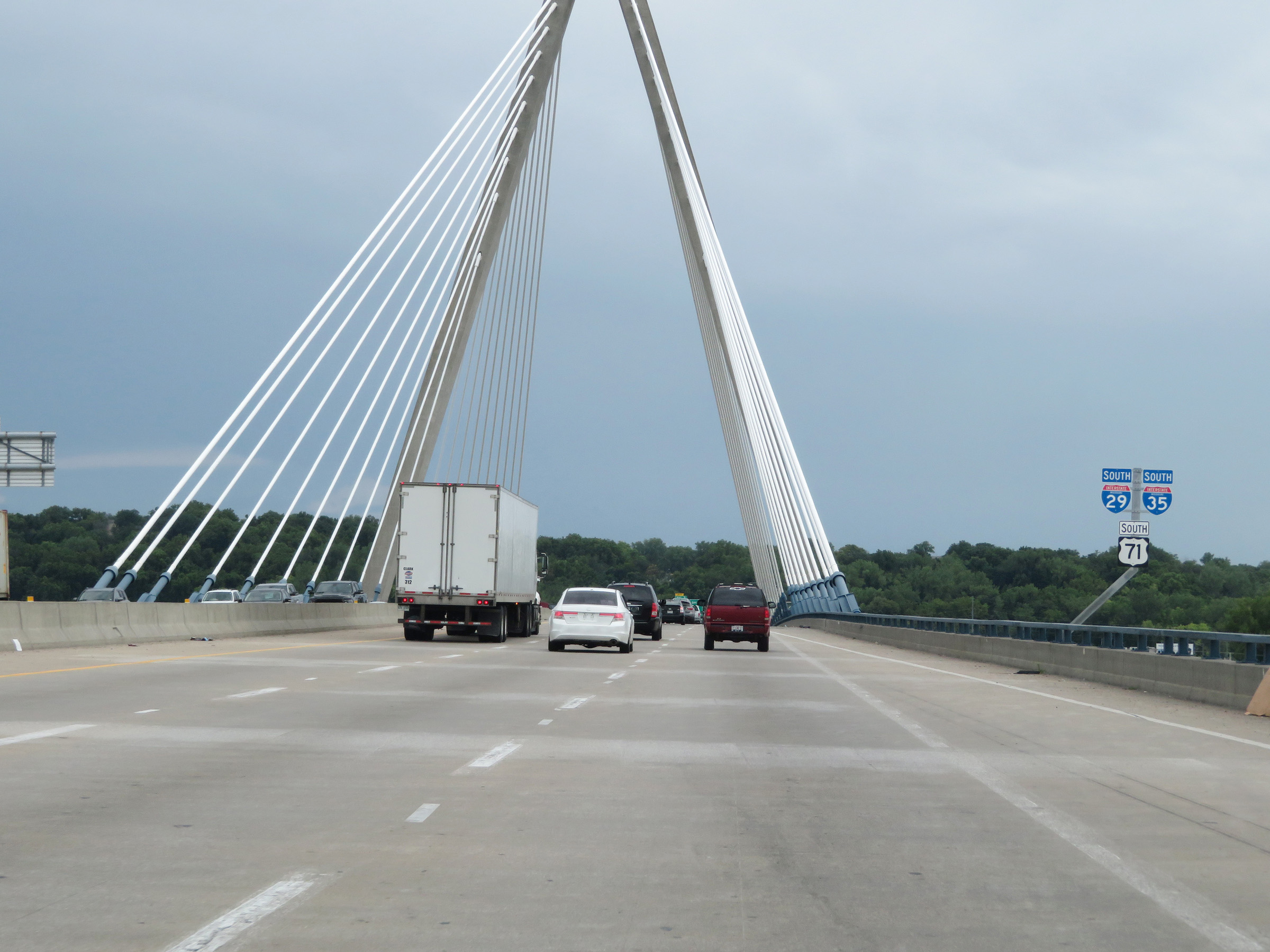
 |
View of the Christopher S. Bond Bridge as it crosses the Missouri River on Interstate 29 South / Interstate 35 South, approaching downtown Kansas City. (Photo taken 8/10/20). |
 |
Interstate 29 South / Interstate 35 South at Exit 4B: Front St / Grand Blvd (Photo taken 8/10/20). |
 |
View on Interstate 29 South / Interstate 35 South at mile marker 4.8. (Photo taken 8/10/20). |
 |
Interstate 29 South / Interstate 35 South at mile marker 4.4. (Photo taken 8/10/20). |
 |
Interstate 29 South / Interstate 35 South at Exit 4A: To US 24 - The Paseo (Photo taken 8/10/20). |
 |
Advance signage for Exit 3, which will be the junction of Interstate 70 and the southern terminus of Interstate 29. (Photo taken 8/10/20). |
 |
As Interstate 29 South / Interstate 35 South enter the downtown area, the maximum speed limit decreases to 45 mph. (Photo taken 8/10/20). |
 |
Traffic to Oak Street, Grand-Walnut, and Downtown should keep right to stay on Interstate 35 South and follow it to Exit 2F. (Photo taken 8/10/20). |
 |
Interstate 29 South / Interstate 35 South at Exit 3: Interstate 70 East / US 40 East / US 71 South - St. Louis (Photo taken 8/10/20). |
 |
A closer view of the ramp to Interstate 70 East / US 40 East / US 71 South via Exit 3 as Interstate 35 South curves hard to the west and Interstate 29 reaches its southern terminus. (Photo taken 8/10/20). |
 |
Coming out of the curve, we see Interstate 70 West traffic on the left and the on ramp from Independence Ave / Troost Ave on the right. (Photo taken 8/10/20). |
 |
Interstate 29 END marker approaching Exit 2F on Interstate 35 South. (Photo taken 8/10/20). |